Saturday, December 27, 2014

Geomagnetic Past

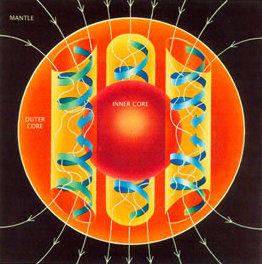
Convection currents of magma
in the outer core

With the paleomagnetic record as leading indicator, Earth's magnetic poles are poised to reverse within the next few thousand years.

Earth's Magnetic Field

A molten iron core generates Earth's magnetic field. Loosely analogous to an electrical generator, Earth's magnetic field is created by the convection of magma in its outer core.

The turbulent convection of molten iron is driven by radioactive heating. This movement produces electrical and magnetic energy. The currents cause the magnetic field surrounding the planet.

Geomagnetism is an ongoing and self-sustained process provided there is sufficient energy to convect flow in the outer core.

Geophysicists attribute shifting currents within the molten core as the cause for the drifting of the magnetic poles. Magnetic North drifts about 10 miles a year.

The positions of Magnetic North and Magnetic South appear destined to flip-flop as they have many times over the course of many millions of years.
What's past is prologue
William Shakespeare, The Tempest.
Ancient Polarity

Geomagnetic reversals have occurred frequently over the past 169 million years. Paleomagnetic evidence is found in rocks on the ocean floor and in some lava flows.
Geomagnetic polarity is shown (image right) as time descends back in time from present day (top) to the Jurassic period (bottom). Polarity has flipped between the normal configuration we observe today (black stripes) and the reverse configuration we observe in the paleomagnetic record (white stripes).

The Cenozoic era ranges from present day to 66 million years ago. The Mesozoic era ranges from the beginning of the Cenozoic era to 252 million years ago. The Cenozoic, known also as the Age of Mammals, is derived from a composite of the Greeks words for new and life.
Conscience is our magnetic compass; reason our chart.
Joseph Cook

REFERENCES

Saturday, December 20, 2014

Earthly Naming

B-15
Massive icebergs are given names. Lesser icebergs remain nameless. B-15 is the largest recorded iceberg.

Naming is curious and profoundly human.

Icebergs are named when they exceed an arbitrary length threshold.

If an iceberg has one side at least 12 miles long, it is named and tracked by the U.S. National Ice Center.

The side-length naming threshold has the unintended consequence of leaving massive, roundish-shaped icebergs unnamed. An unnamed 64 square mile iceberg was spotted three weeks ago adrift in the South Atlantic Ocean.

Unnamed iceberg in the South Atlantic Ocean
NASA Operational Land Imager, 3 December 2014

This particular unnamed iceberg has the same surface area as an entity we've deemed name-worthy: Galveston Island.

Why does William Shakespeare's character Juliet ask Romeo what's in a name?
Juliet: What's in a name? That which we call a rose
By any other name would smell as sweet.
She asks what's in a name because the star-cross'd lovers are burdened with names from two warring families. Juliet laments a person's name is an artificial — and in their case, an irrelevant — convention.

Why do humans name things?

Naming is conventional and arbitrary. Naming objectifies. Naming gives us the illusion of control and the illusion of mastery over — or separateness from — the natural world.

Yet what would we do without naming? The negative aspects of objectifying things also grease the skids for interpersonal communication. Naming gives us a hand-hold on the abstract, the complex, and the poetic.

Naming gives us a handle to things. A personified handle is expressed in this passage from Anne of Green Gables:
Anne:What is the name of that geranium on the window-sill, please?
Marilla:That's the apple-scented geranium.
Anne:Oh, I don't mean that sort of a name. I mean just a name you gave it yourself. Didn't you give it a name? May I give it one then? May I call it—let me see—Bonny would do—may I call it Bonny while I'm here? Oh, do let me!
Marilla:Goodness, I don't care. But where on earth is the sense of naming a geranium?
Anne:Oh, I like things to have handles even if they are only geraniums. It makes them seem more like people.
— Excerpt from Anne of Green Gables
Names have a historical narrative rarely considered. Some names are compounded from others, like iceberg.


Names move in and out of favor. Iceberg floated into existence.


REFERENCES

Saturday, December 13, 2014

Original Water

More than two thirds of Earth's surface is covered by water.


The Asteroid Belt
If Earth's primordial water was boiled off from the intense heat during planetary cooling, where did Earth's abundant water originate?

The origin of Earth’s water remains a mystery.

A prevailing hypothesis is that Earth's water came later from collisions with water-bearing comets or proto-planets from the outer reaches of the Asteroid Belt

Recent analysis of the composition of water sampled on comet 67P suggest Earth's water might not have come from cometary collisions (Life from Comet Collisions).

Scientists suggest that one key to solving the mystery of Earth's abundant water is found in the D/H ratio or the flavor of waterThe D/H ratio is the proportion of Deuterium (symbol D) to Hydrogen (symbol H). The ratio of these two hydrogen isotopes might provide clues to the origin of Earth's water.

Deuterium is a form of hydrogen (i.e., hydrogen isotope) that has an additional neutron not present in common hydrogen. There are about 6,420 hydrogen atoms for every deuterium atom found in the world's oceans.

Deuterium can replace hydrogen in water molecules. The properties of D2O differ from H2O (common water). D2O is called heavy water because it's 10.6% denser than H2O. D2O is also more viscous than H2O.
The current opinion that science and poetry are opposed is a delusion. On the contrary science opens up realms of poetry where to the unscientific all is a blank. Those engaged in scientific researches constantly show us that they realize not less vividly, but more vividly, than others, the poetry of their subjects.
Herbert Spencer, Education, Intellectual, Moral, and Physical (1861)
Analysis of the composition of water sampled on comet 67P, along with previous D/H analysis of other comets show a range of ratios generally containing higher amounts of deuterium than Earth.

Deuterium to Hydrogen Ratio in the Solar System
Source: ESA

Of the deuterium to hydrogen ratios detected in the solar system, the European Space Agency reports:
Of the 11 comets for which measurements have been made, it is only the Jupiter-family Comet 103P/Hartley 2 that was found to match the composition of Earth’s water.
The D/H ratio of water sampled on comet 67P is three times greater than that of Earth's oceans.

Scientists are are turning their attention to asteroids. Meteorites from asteroids in the Asteroid Belt have a closer match to the D/H ratio of water on Earth. Meteorites have a much lower water content than comets. However multiple serious of meteorite bombardments could have produced Earth's oceans.

Water does not resist. Water flows. When you plunge your hand into it, all you feel is a caress. Water is not a solid wall, it will not stop you. But water always goes where it wants to go, and nothing in the end can stand against it. Water is patient. Dripping water wears away a stone.
Margaret Atwood, The Penelopiad

REFERENCES

Saturday, December 6, 2014

Gravity Potato

GRACE satellite data
As mass goes, so goes gravity.

The earthward acceleration of gravity varies by about 0.5% over the surface of the Earth because of unevenly distributed mass.

Exaggerated data visualizations depict the dissymmetrical variations in Earth's gravity field.

Time and Location

Gravitational pull varies by location because of unevenly distributed mass in the oceans, continents, and deep interior. Climate-related variables, like continental water balance, and the accumulation or ablation of glaciers, causes the distribution of mass to vary over time.

Measuring G-Force

The local gravitational field is measured using a gravimeter. A gravimeter is an accelerometer that measures the earthward acceleration of gravity or G-force.

Gravity Potato

Variations in Earth's gravity field is shown in an image known as the Potsdam Gravity Potato. The Potsdam Gravity Potato is derived from a gravity field model produced by the German Research Center for Geophysics (GFZ).

Geoid: The Potsdam Gravity Potato

Some 800 million observations support GFZ's gravity field model. Supporting data were obtained from:
  • LAGEOSGRACE , and GOCE satellites;
  • Ground-based gravity measurements; and
  • Satellite altimetry data.

Attraction Mystery

Gravity is a natural phenomenon wherein physical bodies attract each other. Gravity gives weight to physical objects and causes objects to fall when dropped.
Because there is a law such as gravity, the universe can and will create itself from nothing.
Stephen Hawking
Gravity is one of four fundamental forces. Gravitation acts across the universe. Earth's gravitation is part of the human experience mediating nearly everything we do.
Most gravity has no known origin. Is it some exotic particle? Nobody knows.
Neil deGrasse Tyson

REFERENCES

Saturday, November 29, 2014

Persistent Ice

Glacial ice is the largest freshwater reservoir on Earth. Glaciers are persistent bodies of ice that form where the accumulation of snow exceeds its ablation.

Glaciers account for a significant portion of the world's cryosphere.

ablationThe opposite of accumulation, ablation refers to processes that remove snow, ice, or water from a glacier (melting, evaporation, sublimation, calving, or wind erosion).
calvingCalving is the severing of chunks of ice at the terminus of a glacier.
cryospherePortions of Earth where water is in solid form (e.g., sea ice, lake ice, river ice, snow cover, glaciers, ice caps, ice sheets, and frozen ground).
sublimationSublimation is the conversion from the solid to the gaseous phase of water, without an intermediate liquid stage.

Calving at the terminus of the Perito Moreno Glacier in western Patagonia

Glaciers slowly deform and flow from the force of gravity.
The wintry clouds drop spangles on the mountains. If the thing occurred once in a century historians would chronicle and poets would sing of the event; but Nature, prodigal of beauty, rains down her hexagonal ice-stars year by year, forming layers yards in thickness. The summer sun thaws and partially consolidates the mass. Each winter's fall is covered by that of the ensuing one, and thus the snow layer of each year has to sustain an annually augmented weight. It is more and more compacted by the pressure, and ends by being converted into the ice of a true glacier, which stretches its frozen tongue far down beyond the limits of perpetual snow. The glaciers move, and through valleys they move like rivers.
John Tyndall, 1861

Grinnell Glacier 1938
Grinnell Glacier 2009

Unlike seasonal snow cover, freshwater ice, or transient sea ice that lasts perhaps a few years, a water particle in a glacier can remain frozen 10-100,000 years longer.
A man who keeps company with glaciers comes to feel tolerably insignificant by and by.
Mark Twain, 1880
99% of glacial ice resides within vast ice sheets cover the poles. Deep ice in East Antarctica might be approaching a million years in age.
The truth is, that those who have never entered upon scientific pursuits know not a tithe of the poetry by which they are surrounded.
Herbert Spencer, 1889

REFERENCES

Saturday, November 22, 2014

Life from Comet Collisions

The biosphere covering Earth remains a deep mystery. Where did life originate?

Bioluminescent dinoflagellates lighting a breaking wave at midnight

Earth might well have coalesced from cosmic dust and gas. Billions of years later, a thin raft surrounding Earth teems with co-dependent organisms.
The question of the origin of life is essentially speculative. We have to construct, by straightforward thinking on the basis of very few factual observations, a plausible and self-consistent picture of a process which must have occurred before any of the forms which are known to us in the fossil record could have existed.
John Desmond Bernal
Where did the ingredients for the simplest unicellular life forms come from? Life's ingredients might have come from comets.
Early Earth was not very hospitable when it came to jump-starting life. In fact, new research shows that life on Earth may have come from out of this world.
Astrobiology Magazine
Comet Hale Bopp
Comets are vestiges from the formation of our solar system some 4.5 billion years ago. Comets that move into range of space travel, arrive well-preserved from the freeze locker of the outer solar system.

As it travels near the Sun and Earth, a disintegrating comet represents a treasure-trove of hard data about conditions present during the early stages of the solar system.

The composition of comets interests us because scientists posit that life-building organic compounds might have come from icy comets that collided with Earth millions of years ago.

Organic compounds form the basis of proteins and nucleobases (the building blocks of DNA and RNA). Oceans might have been formed from icy comets and asteroids crashing into Earth.

The first comet landing of a robotic spacecraft touched down on Comet 67P on November 12, 2014. Until then, our knowledge of comets came from a handful of flyby space missions

Comet 67P

Comet 67P
The robotic lander Philae bounced to rest on Comet 67P more than 10 years after being launched from Earth by the European Space Agency.

The Philae landing was a historical touchdown on a comet nucleus.

Philae transmitted in-situ data that will enable scientists to determine the composition of the comet's surface material.

Our Quest

Comets were once believed to be harbingers of human destruction by anthropomorphic gods. Our understanding of our habitat and origin accrues through scientific discovery.


Scientific discovery yields physical explanations to mysterious and once feared phenomena. Our appreciation of the far-fetched phenomena of life grows with every scientific revelation.
Our quest to solve the existential puzzle continues.
The origin of life is a complex narrative of improbable events. The lineage of events stretch back perhaps 13.8 billion years to the Big Bang or beyond.


REFERENCES

Saturday, November 15, 2014

Motion Instruments

Earth's crust has seven or eight plates that drift on a softer mantle. The motions of the plates is described by the universally accepted theory of plate tectonics. Plate tectonics extends a preceding theory of continental drift popular in the early to mid 20th century.
It must have appeared almost as improbable to the earlier geologists, that the laws of earthquakes should one day throw light on the origin of mountains, as it must to the first astronomers, that the fall of an apple should assist in explaining the motions of the moon.
Charles Lyell, Principles of Geology (1830-3), Vol. 3, 5.
Evidence of the motion of the plates comes from technologies like Interferometric Synthetic Aperture Radar (InSAR) and Global Positioning Systems (GPS).

InSAR

Interferometric synthetic aperture radar (InSAR) streams data to a satellite that records ground surface movements to within an inch. InSAR technology was first used to analyze the 1992 Landers earthquake.

InSAR has since provided data for variety of earthquakes including the M7.6 1999 Izmit earthquake that caused extensive damage and loss of life.

Surface motion caused by the Izmit earthquake is shown in the interferogram below which depicts surface changes. The interferogram used pairs of images from InSAR data recorded shortly before, and a month after, the earthquake event.

1999 Izmit, Turkey Earthquake Interferogram

Each color contour represents 1.1 inches (28 mm) of vertical displacement (toward the satellite), or 2.8 inches (70 mm) of horizontal movement. The thin, east-west red lines show the location of fault breaks. The thicker, east-west black lines show a fault rupture inferred from the data.

The Izmit earthquake occurred along the boundary of the Anatolian Plate and the Eurasian Plate (right).

The North Anatolian Fault broke during the Izmit earthquake event moving more than 8 feet to produce the pattern in the interferogram.

"Though the theories of plate tectonics now provide us with a modus operandi, they still seem to me to be a periodic phenomenon. Nothing is world-wide, but everything is episodic. In other words, the history of anyone part of the earth, like the life of a soldier, consists of long periods of boredom and short periods of terror."
— Derek Victor Ager, The Nature of the Stratigraphical Record, 3rd Ed. 1993, 141.

GPS

Another means to record earthquake-induced displacement is to use GPS. A marker bolt is drilled into the ground. The coordinates of the bolt are recorded using a GPS device. The coordinates of the bolt are recorded again at a later date to determine if movement has occurred. Consumer GPS devices are accurate to within several meters. Measuring earthquake movements requires a finer resolution GPS receiver that uses the phase of the signal to increase accuracy to within millimeters.

Visualization of a Strike-Slip Fault

"We are all glorified motion sensors.

Some things only become visible to us when they undergo change.

We take for granted all the constant, fixed things, and eventually stop paying any attention to them. At the same time we observe and obsess over small, fast-moving, ephemeral things of little value.

The trick to rediscovering constants is to stop and focus on the greater panorama around us. While everything else flits abut, the important things remain in place.

Their stillness appears as reverse motion to our perspective, as relativity resets our motion sensors. It reboots us, allowing us once again to perceive.

And now that we do see, suddenly we realize that those still things are not so motionless after all. They are simply gliding with slow individualistic grace against the backdrop of the immense universe.

And it takes a more sensitive motion instrument to track this."


Vera Nazarian, The Perpetual Calendar of Inspiration

REFERENCES

Saturday, November 8, 2014

Falls

Urami Waterfall
by Kobayashi Kiyochika
Waterfalls are formed when a river is young, but formation gradually occurs over several thousand years.

Rivers flow over strata of rock that vary in resistance to erosion. As rapid river flow scours a channel into a less erosion-resistant stratum below, it transports loose material downstream thus increasing the slope of the watercourse.

As the flowing water carries the softer rock downstream, the riverbed becomes steeper. Gradually the slope increases to the point where rapids become a waterfall.

As a plunge pool develops, turbulence and whirlpools in the water undercuts the soft rock.

Illustration by Jerry Crimson Mann
After a long period as a fully-formed waterfall, the hard rock overhang can slowly retreat upstream to form a river canyon as the hard rock is eventually eroded and carried downstream.
“When I was walking in the mountains with the Japanese man and began to hear the water, he said, 'What is the sound of the waterfall?' 'Silence,' he finally told me.”
Jack Gilbert, Collected Poems

Selandjafoss, Iceland
by Martin Meeks

Man is not himself only...He is all that he sees; all that flows to him from a thousand sources...He is the land, the lift of its mountain lines, the reach of its valleys.
Mary Hunter Austin

REFERENCES

Saturday, November 1, 2014

Everything is Hitched

John Muir wrote,
"When we try to pick out anything by itself, we find it hitched to everything else in the Universe." 
Wolf Reintroduction, January 1995.
What-eats-what in the biosphere is a dynamic web where organisms are hitched. Consider the grey wolf.

Grey wolves were extirpated from Yellowstone by the mid-1920s. During the winters of 1995-96 wolves were re-introduced to the park after a 70-year absence.

This ecological tinkering has allowed scientists to study a textbook example of a trophic cascade.

Trophic cascades occur when a predator reduces the population of its prey. This population reduction cascades to release the next trophic level from predation. Grey wolves are apex predators. Grey wolves have gradually surpressed the population of elk in the park since their reintroduction.

Eleven-member wolf pack in winter, Yellowstone National Park, 2001

Elk are ruminant mammals. They consume grasses, plants, leaves, and bark.

The suppression of the elk population has enabled plant species like aspen, cottonwood, and willow to flourish. Scientists have observed the top-down impact of the grey wolf since its reintroduction in Yellowstone 15 years ago. The abundance and diversity of plant species have increased.

Source: Trophic cascades in Yellowstone: The first 15 years after wolf reintroduction

Aldo Leopold first described the concepts of trophic cascades after observing the overgrazing of mountain slopes following the extermination of wolves.
“We reached the old wolf in time to watch a fierce green fire dying in her eyes. I realized then, and have known ever since, that there was something new to me in those eyes – something known only to her and to the mountain. I was young then, and full of trigger-itch; I thought that because fewer wolves meant more deer, that no wolves would mean hunters’ paradise. But after seeing the green fire die, I sensed that neither the wolf nor the mountain agreed with such a view.”
Aldo Leopold
Bottom-up cascades also occur. Changes in the abundance and diversity of plants will directly impact higher level predation and population.
“Only the mountain has lived long enough to listen objectively to the howl of the wolf.”
Aldo Leopold
Wolves howling at the moon is a compelling myth. A howling wolf is a plaintive reminder of our existential connection to all living things. Seeing constellations in the night sky while wolves howl harkens us to consider our place in the cosmos. We are bound to a thin band of life that covers the Earth. Everything is hitched.


REFERENCES

Saturday, October 25, 2014

Earthrise

NASA's unmanned Lunar Orbiter 1 gave us an unprecedented image of Earth rising above the lunar surface in 1966.

Today, 17595 days after the first Earthrise image, the Moon has made 644 trips around Earth.

The Moon orbits Earth every 27.322 days. As the Moon orbits Earth, it synchronously rotates on its axis.

The Moon rotates 360° in 27 days. Because the Moon orbits Earth every 27.322 days, it exposes the same face to an Earthbound observer.

Near Side Far Side

The face of the Moon we see is called the near side. The opposite side is called the far side, or the dark side. Dark side is a misnomer because when the Moon is dark during a new phase, the far side is bathed in sunlight.

31 Moon orbits after the 1966 Lunar Orbiter 1 gave us the iconic image of Earth rising above the lunar horizon, Apollo 8 astronauts were orbiting around the Moon in December 1968.
Earthrise Above Lunar Surface
August 23, 1966
"I happened to glance out of one of the still-clear windows just at the moment the earth appeared over the lunar horizon. It was the most beautiful, heart-catching sight of my life, one that sent a torrent of nostalgia, of sheer homesickness, surging through me. It was the only thing in space that had any color to it."
Frank Borman, Commander of Apollo 8
Firsts

The Apollo 8 astronauts were the first people to leave Earth's orbit; the first people to see the whole Earth; and the first people to see the far side of the Moon.
In space there are countless constellations, suns and planets; we see only the suns because they give light; the planets remain invisible, for they are small and dark. There are also numberless earths circling around their suns.”
Giordano Bruno, Despre infinit univers si lumi, 1584.

REFERENCES

Saturday, October 18, 2014

Deep Time

Einstein mused about the illusive nature of distinguishing past, present, and future.
"People like us, who believe in physics, know that the distinction between past, present, and future is only a stubbornly persistent illusion."
Albert Einstein
An eon in common parlance, is a very long period of time:
e·on/ˈēən,ˈēˌän/noun.an indefinite and very long period of time, often a period exaggerated for humorous or rhetorical effect.
usage: She reached the hilltop cairn eons before my arrival.
An eon acquires the specificity a billion years for geologists and astronomers. Radiometric dating indicates Earth is 4,540,000,000 years old. This translates to about four and one half eons.
“Four days will quickly steep themselves in nights;
Four nights will quickly dream away the time.”

William Shakespeare, A Midsummer Night's Dream

Deep Time

Þingvellir
by Hansueli Krapf
Earth is roughly 57 million times older than the longest average human life expectancy. Perhaps the 56,750,000-fold difference explains why geologic time is baffling.

Geologic time is also referred to as deep time.

Comparing deep time to human time in Basin and Range, John McPhee borrows a metaphor cited from Stephen Jay Gould's Time's Arrow, Time's Cycle:

Consider the Earth's history as the old measure of the English yard, the distance from the King's nose to the tip of his outstretched hand. One stroke of a nail file on his middle finger erases human history.

Some geologic phenomena occur in real-time like the calving of a glacier, the flow of lava from a volcano, or the formation of a tropical cyclone.

Most geologic phenomena occur on a geologic time scale like continental drift — for example the pulling apart of the North American and Eurasian Plates at Þingvellir in southwestern Iceland.

Geologists have trained themselves to imagine events unfolding in units of time no smaller than a million years. The intersection of human time and geologic time excites our curiosity.
“If you free yourself from the conventional reaction to a quantity like a million years, you free yourself a bit from the boundaries of human time. And then in a way you do not live at all, but in another way you live forever.”
John McPhee, Annals of the Former World

Image: Tobias Alt

"The mind seemed to grow giddy by looking so far into the abyss of time."
John Playfair, remarking on the strata of the unconformity at Siccar Point

If one lives to be 100 years old, Earth will still be some 45 million years older.

REFERENCES

Saturday, October 11, 2014

Fish Migration

Photo by Matthew Hoelscher
Many marine fish regularly migrate over distances ranging from a few meters to thousands of kilometers. The migration time scale ranges from daily to annually, or longer.

Significant long-term fisheries migrations are likely to occur due to the impact of climate change on ocean temperatures.

Marine Biologists predict a large-scale poleward shift of marine fish and invertebrates using measurable data and computer simulations known as species distribution models (SDM).
"As fish move to cooler waters, this generates new opportunities for fisheries in the Arctic. On the other hand it means it could disrupt the species that live there now and increase competition for resources.”
― Miranda Jones, a University of British Columbia Nereus Fellow

Worst Case Best Case
Earth’s oceans warm by 3° C by 2100Earth’s oceans warm by 1° C by 2100
Fish migrate poleward from current habitats at a rate of 26 km (16 miles) per decade.Fish migrate poleward from current habitats at a rate of 15 km (9 miles) per decade.

“So there is a kind of terrible irony that at the point that we are best able to understand and appreciate and value the richness of life around us, we are destroying it at a higher rate than it has ever been destroyed at all.”
Douglas Adams, excerpt from Parrots, the Universe and Everything

Three SDMs AquaMaps, Princeton's Maxent model, and the Dynamic Bioclimate Envelope Model were used by Miranda Jones and William Cheung from the University of British Columbia Fisheries Centre to analyze the world oceans and predict patterns of change in fish species:

Atlantic Bluefin Tuna
Photo by Danilo Cedrone

“The tropics will be the overall losers. This area has a high dependence on fish for food, diet and nutrition. We’ll see a loss of fish populations that are important to the fisheries and communities in these regions.”
― William Cheung, University of British Columbia Fisheries Centre

REFERENCES

Saturday, October 4, 2014

Mountains of the Deep

Seamounts are the mountains of the deep. A seamount is typically an extinct submerged volcano that has risen from the seafloor.

The New England Seamount Chainin the Atlantic Ocean

Bear Seamount - oldest seamount in the New England Seamount Chain

If enough volcanic material erupts, and the material is amassed atop itself, a seamount can rise above sea level to become a high island like the Hawaiian Islands.

Many volcanoes go dormant or become extinct to remain seamounts below sea level.
“We are like islands in the sea, separate on the surface but connected in the deep.”
William James
Seafloor mapping missions are still discovering new seamounts.
“What is wanted is not the will to believe, but the will to find out, which is the exact opposite.”
Bertrand Russell
Gravity fields recorded by the NASA Jason-1 satellite, combined with gravity measurements from the ESA CryoSat-2 satellite, have enabled scientists to map thousands of previously uncharted seamounts.

Seamount southeast of Jarvis Island
Last August, while delineating the extent of the U.S. continental shelf in the Pacific Ocean using a multi-beam echosounder, scientists discovered a 3,600 ft seamount 186 miles southeast of Jarvis Island in the South Pacific.

“We shall not cease from exploration
And the end of all our exploring
Will be to arrive where we started
And know the place for the first time.”
T.S. Eliot, Four Quartets

REFERENCES

Saturday, September 27, 2014

Over the Pass

A pass is a route over a mountain range.

The route of a mountain pass typically takes advantage of a low point in a ridge called a topographic saddle.

Saddle point (red dot)
A topographic saddle is analogous to a saddle point in mathematics.

A saddle point, indicated by a red dot (right), marks the lowest point along a ridge that also represents the highpoint between two valleys.

Finding passage through a mountain range is often a matter of locating a saddle. A saddle is also known as a gap, a notch, or a col.

Arthur Cayley advanced a theory of continuous surfaces in 1859 which is the mathematical foundation for contemporary topographic maps. Cayley proposed contour lines connecting points of constant elevation and slope lines perpendicular to the contour lines. Such maps assist hikers planning a route through mountainous terrain.

Over every mountain there is a path, although it may not be seen from the valley.
Theodore Roethke

View below the Beartooth Pass, 19 September 2014

Historically mountain ranges have been formidable barriers to human travel. Mountain passes have played a role in migration, trade, and battle. Khyber Pass is part of the ancient Silk Road which has been a trade route between Central and South Asia for centuries.

Notable Mountain Passes
Thorung La17,769 ftThrough the Damodar Himal, north of the Annapurna Himal, in central Nepal.
Beartooth10,947 ftThrough the Beartooth Moutains on the border of Montana and Wyoming.
Donner7,056 ftThrough the northern Sierra Nevada, above Donner Lake.
Brenner4,495 ftThrough the Alps along the border between Italy and Austria.
Khyber3,510 ftPart of the Silk Road connecting Afghanistan, Pakistan and India through the northeastern part of the Safēd Kōh mountains.

It is not the mountain we conquer but ourselves.
Edmund Hillary

REFERENCES

Saturday, September 20, 2014

Nature Beckons

Paul Hawken's commencement address to the University of Portland class of 2009 is a call to action:
You are going to have to figure out what it means to be a human being on earth at a time when every living system is declining, and the rate of decline is accelerating. Kind of a mind-boggling situation... but not one peer-reviewed paper published in the last thirty years can refute that statement. Basically, civilization needs a new operating system, you are the programmers, and we need it within a few decades.

— Excerpt from Paul Hawken's commencement address.
Civilization's operating system, seized up by superstition, fear, ignorance and tribalism, seems destined to a harrowing ride toward extinction.

While there might not be subsistence-wage jobs for graduates, there is perhaps an existential mission. Hawken's speech is titled,
You are Brilliant, and the Earth is Hiring


The plea to reboot comes from the motherboard of rational thinking, self-awareness, and introspection.

Hawken's message is inspired by the sublimities that surround us:
Ralph Waldo Emerson once asked what we would do if the stars only came out once every thousand years. No one would sleep that night, of course. The world would create new religions overnight. We would be ecstatic, delirious, made rapturous by the glory of God. Instead, the stars come out every night and we watch television.

— Excerpt from Paul Hawken's commencement address


Nature Beckons

Earth's abundance has obscured the realization that civilization has been motivated by self-interest and ruled by ignorance and fear. Nevertheless hope springs forth with each generation.
They got distracted and lost sight of the fact that life is a miracle every moment of your existence. Nature beckons you to be on her side. You couldn’t ask for a better boss. The most unrealistic person in the world is the cynic, not the dreamer. Hope only makes sense when it doesn’t make sense to be hopeful. This is your century. Take it and run as if your life depends on it.

— Closing from Paul Hawken's commencement

REFERENCES

Saturday, September 13, 2014

Geothermal Energy

What is the origin of the heat energy erupting from Earth's surface?

Earth formed by accretion from solar nebula — an interstellar cloud of dust, hydrogen, helium and other ionized gases — about 4,540,000,000 years ago.

Extreme volcanism and collisions with other bodies made much of the nascent planet's surface molten. Volcanic gases formed a fledgling atmosphere.

Bárðarbunga Volcano, 4 September 2014
Image: Peter Hartree

As the planet cooled, it formed a solid crust. Rocks in the core and mantle remain hot from the original materials colliding at high speeds.
Terminology:
Magma refers to molten rock still underground. If molten rock erupts onto the surface, it is called lava. Lava is liquified rock at 1,292 to 2,192 °F (700 to 1,200 °C).
Bárðarbunga Volcano, 2 September 2014
Image: Arctic-Images/Corbis

Collision energy is the source of heat trapped below Earth's crust. Heat below Earth's crust is called geothermal energy.
May not subterraneous fire be considered as the great plough which Nature makes use of to turn up the bowels of the earth?
Sir William Hamilton


REFERENCES

Saturday, September 6, 2014

Inhospitable Beauty

Acidic lakes can form in volcano craters because of volcanic gases creating a stunning, but inhospitable environment.
Never say there is nothing beautiful in the world anymore. There is always something to make you wonder in the shape of a tree, the trembling of a leaf.
Albert Schweitzer
Kawah Ijen

The turquoise-colored lake in the crater of the Kawah Ijen volcano appears serene but the water has a prohibitively acidic pH of 0.3 because of an influx of sulfuric gas from the volcano. For comparison, the pH of pure drinking water is 7 (neutral), while the pH of lemon juice is 3.

Acidic lake in Kawah Ijen crater

The Kawah Ijen crater lake the world's largest acidic lake.
Each volcano is an independent machine—nay, each vent and monticule is for the time being engaged in its own peculiar business, cooking as it were its special dish, which in due time is to be separately served.
Clarence Dutton
Kawah Ijen at Night

At night, a blue glow emanates from the cracks in the Kawah Ijen volcano where sulfuric gases are emitted. Sulfuric gas escapes from the subsurface under high pressure and temperatures up to 1,112°F (600°C).

Blue flame of sulfuric gases igniting in the Kawah Ijen crater.
Photograph by Oliver Gunewald

The super-heated stream of sulphuric gas ignites when exposed to atmospheric oxygen causing the intense blue flames observed at night.
At times our own light goes out and is rekindled by a spark from another person. Each of us has cause to think with deep gratitude of those who have lighted the flame within us.
Albert Schweitzer

REFERENCES

Popular