Showing posts with label Magma. Show all posts

Saturday, September 19, 2015

Continental Volcano Chain

Geologists posit that hotspots, expressed on the ground surface as observable volcanic features, are fed by underlying super-heated plumes of mantle materials (shown in red).

The large-scale motion of Earth's lithosphere (shown in yellow) is known as plate tectonics.

Mantle hotspots remain stationary compared to the dynamic shifting of Earth's plates. As the lithosphere moves laterally, chains of volcanic islands in the ocean, or chains of continental volcanoes, form over millions of years.

A noted continental chain was created by the Snake River Plain-Yellowstone hotspot. The Snake River Plain-Yellowstone hotspot is the source of a 400 mile chain of volcanic features created over 15 million years. It extends from what is today the Idaho-Oregon border up intoYellowstone National Park in northwest Wyoming.

The Lava Creek eruption, the most recent significant volcanic event in the chain, occurred some 640,000 years ago causing the Lava Creek Tuff and the Yellowstone Caldera.

The longest continental chain, three times as long as the track caused by the Yellowstone hotspot, has recently been identified in Australia by a team of geologists.

Cosgrove Volcano Track

Geologists have recently identified the longest series of continental volcanoes, named the Cosgrove volcano track. The track spans 1,243 miles across eastern Australia (shown below). Geologists posit that as Australia moved north over a hotspot, volcanic features were created over the course of 33 million years.

Cosgrove volcano track

"We realized that the same hotspot had caused volcanoes in the Whitsundays and the central Victoria region, and also some rare features in New South Wales, roughly halfway between them."
― Dr. Rhodri Davies, Australian National University
Hotspots occur where rocks melt to create flowing magma. Heated by the hot core, fluid rock in the mantle rises and falls. Plumes of magma occasionally penetrate the crust to produce volcanoes. Over millions of years, continental plates move laterally over the hotspots thus creating a travel log expressed by volcanic features marking the surface of the Earth.
"Ultimately this new understanding may help us to reconstruct the past movements of continents from other hotspots."
― Dr. Nick Rawlinson, University of Aberdeen

REFERENCES

Friday, May 15, 2015

Yellowstone Supervolcano

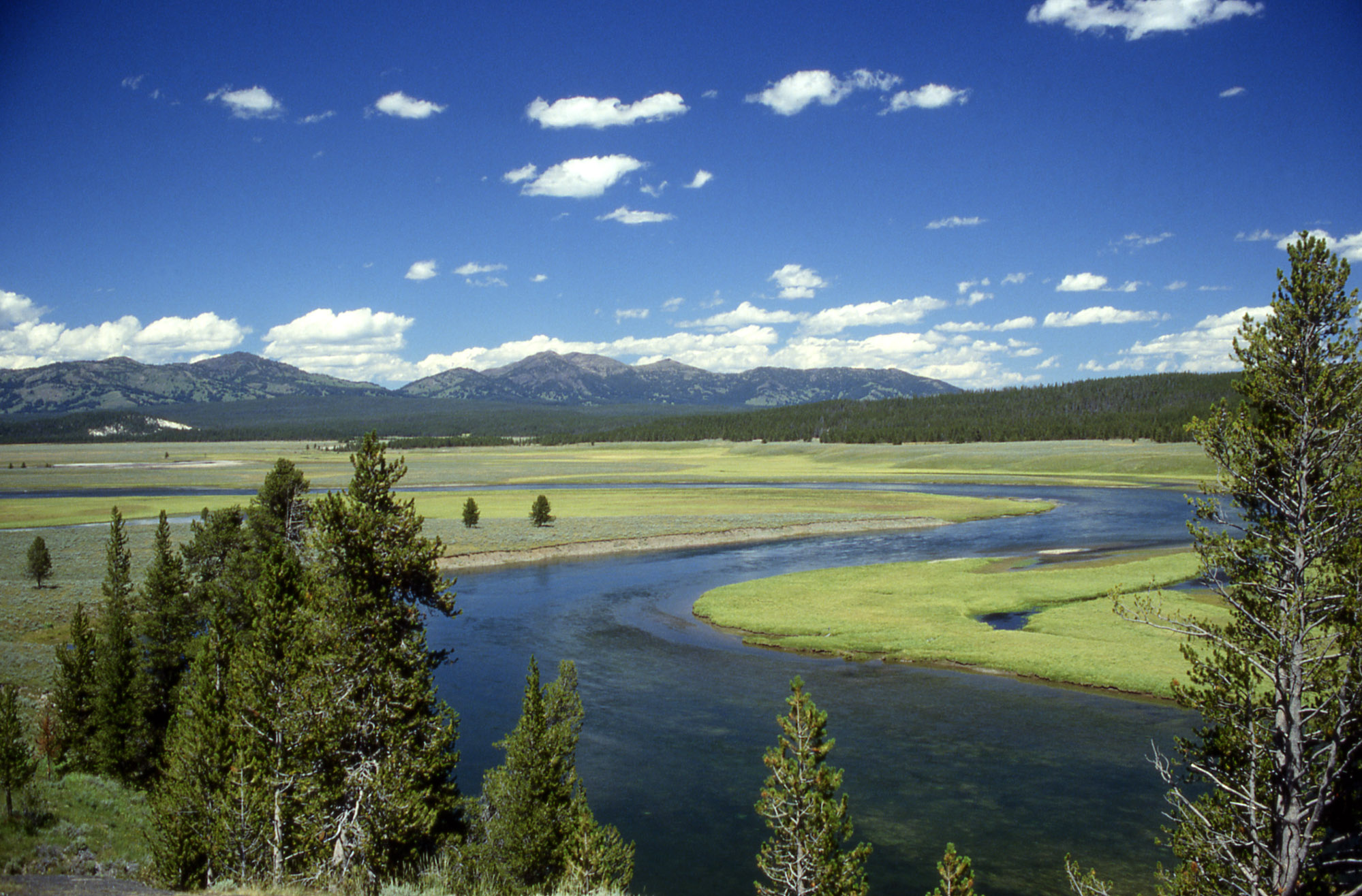
Yellowstone River flowing
through the Yellowstone Caldera
Geophysicists have long recognized that the Yellowstone Caldera, lined by a mountainous ridge and overlying a supervolcano that last erupted 640,000 years ago, covers most of Yellowstone National Park.

A seismic imaging study conducted by geophysicists from the University of Utah indicates the volcanic plumbing and magma chamber underlying Yellowstone is more voluminous than realized.
A volcano may be considered as a cannon of immense size.
— Oliver Goldsmith, Goldsmith’s Miscellaneous Works, 1841
A University of Utah video animation shows the extent of the volcanic plumbing and magma reservoir revealed by the imaging study (below).

Yellowstone magma reservoirSource: University of Utah

Color Key

Green line Yellowstone National Park boundary
Orange Previously known magma chamber (3 - 9 miles beneath the surface)
Red Previously unknown magma reservoir (12 - 28 miles beneath the surface)
Yellow Hotspot plume that supplies molten rock from Earth's mantle
Black line Boundary of the caldera
White dots Epicenters of earthquake data used in the study

Our earth is very old, an old warrior that has lived through many battles. Nevertheless, the face of it is still changing, and science sees no certain limit of time for its stately evolution. Our solid earth, apparently so stable, inert, and finished, is changing, mobile, and still evolving. Its major quakings are largely the echoes of that divine far-off event, the building of our noble mountains. The lava floods and intriguing volcanoes tell us of the plasticity, mobility, of the deep interior of the globe.
— Reginald Aldworth Daly

REFERENCES

Saturday, December 27, 2014

Geomagnetic Past

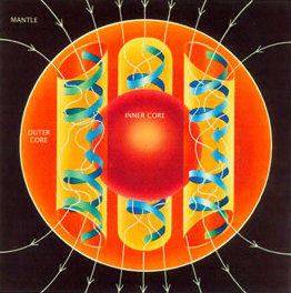
Convection currents of magma
in the outer core

With the paleomagnetic record as leading indicator, Earth's magnetic poles are poised to reverse within the next few thousand years.

Earth's Magnetic Field

A molten iron core generates Earth's magnetic field. Loosely analogous to an electrical generator, Earth's magnetic field is created by the convection of magma in its outer core.

The turbulent convection of molten iron is driven by radioactive heating. This movement produces electrical and magnetic energy. The currents cause the magnetic field surrounding the planet.

Geomagnetism is an ongoing and self-sustained process provided there is sufficient energy to convect flow in the outer core.

Geophysicists attribute shifting currents within the molten core as the cause for the drifting of the magnetic poles. Magnetic North drifts about 10 miles a year.

The positions of Magnetic North and Magnetic South appear destined to flip-flop as they have many times over the course of many millions of years.
What's past is prologue
— William Shakespeare, The Tempest.
Ancient Polarity

Geomagnetic reversals have occurred frequently over the past 169 million years. Paleomagnetic evidence is found in rocks on the ocean floor and in some lava flows.
Geomagnetic polarity is shown (image right) as time descends back in time from present day (top) to the Jurassic period (bottom). Polarity has flipped between the normal configuration we observe today (black stripes) and the reverse configuration we observe in the paleomagnetic record (white stripes).

The Cenozoic era ranges from present day to 66 million years ago. The Mesozoic era ranges from the beginning of the Cenozoic era to 252 million years ago. The Cenozoic, known also as the Age of Mammals, is derived from a composite of the Greeks words for new and life.
Conscience is our magnetic compass; reason our chart.
— Joseph Cook

REFERENCES

Saturday, September 13, 2014

Geothermal Energy

What is the origin of the heat energy erupting from Earth's surface?

Earth formed by accretion from solar nebula — an interstellar cloud of dust, hydrogen, helium and other ionized gases — about 4,540,000,000 years ago.

Extreme volcanism and collisions with other bodies made much of the nascent planet's surface molten. Volcanic gases formed a fledgling atmosphere.

Bárðarbunga Volcano, 4 September 2014
Image: Peter Hartree

As the planet cooled, it formed a solid crust. Rocks in the core and mantle remain hot from the original materials colliding at high speeds.
Terminology:
Magma refers to molten rock still underground. If molten rock erupts onto the surface, it is called lava. Lava is liquified rock at 1,292 to 2,192 °F (700 to 1,200 °C).
Bárðarbunga Volcano, 2 September 2014
Image: Arctic-Images/Corbis

Collision energy is the source of heat trapped below Earth's crust. Heat below Earth's crust is called geothermal energy.
May not subterraneous fire be considered as the great plough which Nature makes use of to turn up the bowels of the earth?
— Sir William Hamilton


REFERENCES

Saturday, March 8, 2014

Terra Firma

Dating of the oldest rocks on Earth sheds light on how the planet cooled to a life-supportable solid crust from a nascent sphere of molten magma. A cathodoluminescence image of a 400-mm zircon crystal found in a remote part of Western Australia known as Jack Hills is dated at 4.4 billion years old.

A zircon crystal estimated to be 4.4 billion years old
John Valley, University of Wisconsin
Penetrating so many secrets, we cease to believe in the unknowable. But there it sits, nevertheless, calmly licking its chops.
― H. L. Mencken
Genesis Rock from the moon.
To date, Jack Hills zircon crystals are the oldest crystals discovered in-situ on the face of the Earth.

The Genesis Rock, collected by Apollo 15 astronauts during their moon landing, has been dated at 4.46 billion years. Although it originated on the Moon, it is one of the oldest known rocks.

Scientists hypothesize that the Earth began orbiting the sun about 4.6 billion years ago. As a molten protoplanet, the Earth needed a cooling period before a rocky crust was formed that was cool enough to support carbon-based organisms. It cooled from its molten state to solid earth. Terra firma is Latin phrase meaning solid earth. Terra translates to earth. Firma translates to solid.
"You're on Earth. There's no cure for that."
— Samuel Beckett
The dating of the Jack Hills crystal suggests that by its 200-millionth birthday, the Earth had a rocky crust.

Chemical hints in the Isua sediments found on the southwestern coast of Greenland suggest life existed as early as 3.8 billion years ago.
"What are men to rocks and mountains?"
— Jane Austen, Pride and Prejudice

REFERENCES

Saturday, January 5, 2013

Caldera Lakes

A volcanic crater lake forms in a cauldron-like volcanic feature called a caldera. Caldera is a Spanish word from the latin caldaria meaning cooking pot.

A caldera lake is formed in several stages following a cataclysmic volcanic eruption.

Crater Lake is a lake that was formed in a caldera from precipitation and snow melt.

Cataclysmic Eruption

During a cataclysmic eruption (below), a fast-moving column of ash, hot gas, and rock escapes from a subsurface magma chamber blasting up through the ground surface and spewing into the atmosphere. As subsurface materials are transported and displaced to the surface, the volume of the magma chamber decreases.

Cataclysmic Eruption

Caldera Collapse

The volcano and land mass above a magma chamber is supported, in part, by the magma itself. As a significant volume of magmatic material is displaced by the eruption, a volcanic summit forms. Vertical fissures formed beneath the summit (below) advance the collapse and subsidence of the displaced volume of erupted material. A conical ring of pumice and ash surround the collapsed summit.

Caldera Collapse

New Caldera

After the ash settles, and the magmatic system finds a new isostatic equilibrium, the remaining surface depression is the newly formed caldera. In the depiction below, ground water interacts with hot deposits causing eruptions of steam.

New Caldera

Caldera Lake

The depression fills with precipitation to become a lake (below). Over time, renewed eruptions from vents in the caldera might form an island in the lake. Wizard Island is a cinder cone that formed an island in Crater Lake.

Caldera Lake


REFERENCES

Popular