It must have appeared almost as improbable to the earlier geologists, that the laws of earthquakes should one day throw light on the origin of mountains, as it must to the first astronomers, that the fall of an apple should assist in explaining the motions of the moon.Evidence of the motion of the plates comes from technologies like Interferometric Synthetic Aperture Radar (InSAR) and Global Positioning Systems (GPS).
— Charles Lyell, Principles of Geology (1830-3), Vol. 3, 5.
InSAR
Interferometric synthetic aperture radar (InSAR) streams data to a satellite that records ground surface movements to within an inch. InSAR technology was first used to analyze the 1992 Landers earthquake.
InSAR has since provided data for variety of earthquakes including the M7.6 1999 Izmit earthquake that caused extensive damage and loss of life.
Surface motion caused by the Izmit earthquake is shown in the interferogram below which depicts surface changes. The interferogram used pairs of images from InSAR data recorded shortly before, and a month after, the earthquake event.
 |
| 1999 Izmit, Turkey Earthquake Interferogram |
Each color contour represents 1.1 inches (28 mm) of vertical displacement (toward the satellite), or 2.8 inches (70 mm) of horizontal movement. The thin, east-west red lines show the location of fault breaks. The thicker, east-west black lines show a fault rupture inferred from the data.
 The Izmit earthquake occurred along the boundary of the Anatolian Plate and the Eurasian Plate (right).
The North Anatolian Fault broke during the Izmit earthquake event moving more than 8 feet to produce the pattern in the interferogram.
"Though the theories of plate tectonics now provide us with a modus operandi, they still seem to me to be a periodic phenomenon. Nothing is world-wide, but everything is episodic. In other words, the history of anyone part of the earth, like the life of a soldier, consists of long periods of boredom and short periods of terror."
— Derek Victor Ager, The Nature of the Stratigraphical Record, 3rd Ed. 1993, 141.
— Derek Victor Ager, The Nature of the Stratigraphical Record, 3rd Ed. 1993, 141.
GPS
Another means to record earthquake-induced displacement is to use GPS. A marker bolt is drilled into the ground. The coordinates of the bolt are recorded using a GPS device. The coordinates of the bolt are recorded again at a later date to determine if movement has occurred. Consumer GPS devices are accurate to within several meters. Measuring earthquake movements requires a finer resolution GPS receiver that uses the phase of the signal to increase accuracy to within millimeters.
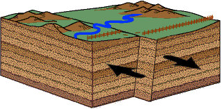 |
| Visualization of a Strike-Slip Fault |
"We are all glorified motion sensors.
Some things only become visible to us when they undergo change.
We take for granted all the constant, fixed things, and eventually stop paying any attention to them. At the same time we observe and obsess over small, fast-moving, ephemeral things of little value.
The trick to rediscovering constants is to stop and focus on the greater panorama around us. While everything else flits abut, the important things remain in place.
Their stillness appears as reverse motion to our perspective, as relativity resets our motion sensors. It reboots us, allowing us once again to perceive.
And now that we do see, suddenly we realize that those still things are not so motionless after all. They are simply gliding with slow individualistic grace against the backdrop of the immense universe.
And it takes a more sensitive motion instrument to track this."
― Vera Nazarian, The Perpetual Calendar of Inspiration
REFERENCES
- Izmit Inteferogram, Wikimedia Commons.
- Interferometric synthetic aperture radar, Wikipedia


